 |
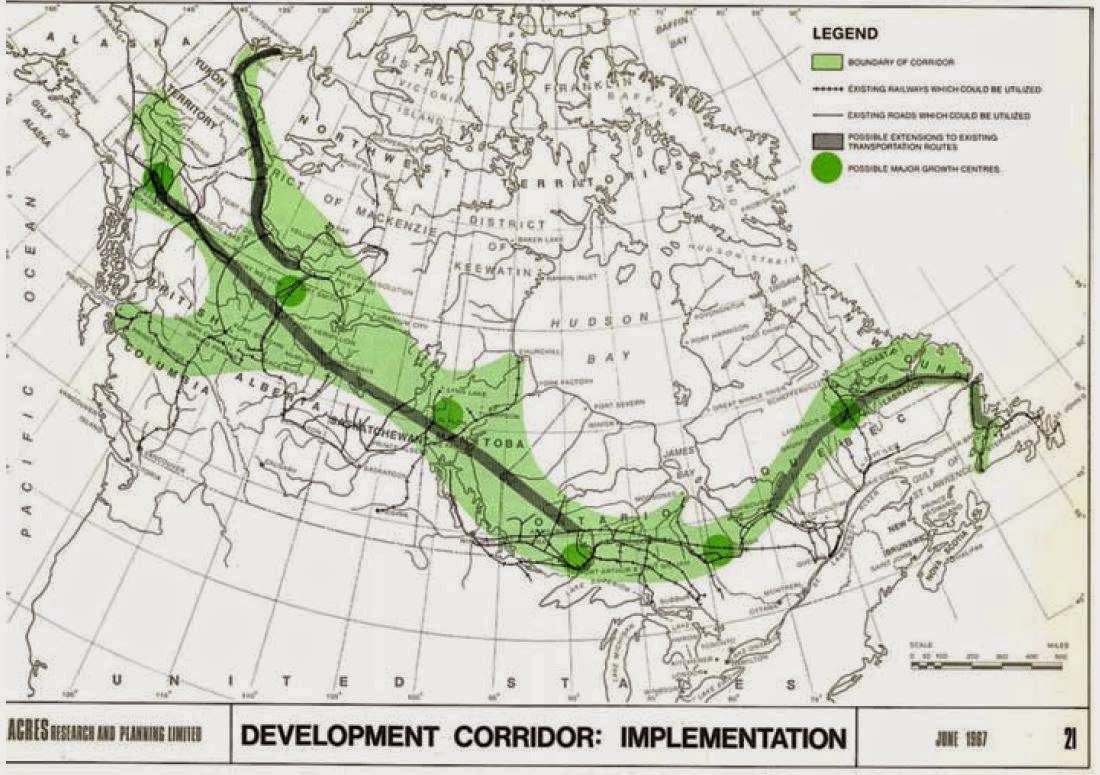
| Proposed larger settlements (green circles) and infrastructure extensions (black lines) in the larger Development Corridor. |
So,
When I was in secondary school, I looked around at the global economic powerhouses and noticed a trend. The ones I identified were the United States, the former Union of Soviet Socialist Republics and China. I noticed that they were big countries, and had something that Canada did not: population density. I hypothesized in my young mind that certainly Europe could become a larger global player if they formed some sort of economic union, and felt vindicated when I later discovered that the European Union was indeed a thing, though it had been conceived long before I had any such idea. So I thought to myself that certainly Canada could become a larger economic power if her more northern climes were developed. How? My thought process was that, if a temporary tax-free zone were established, surely private industry would step in and establish the necessities. It was awfully short on details, but in fairness I think I was 16 when I had this idea.
Naturally, when I found out about the concept of the Mid-Canada Corridor, I was quite excited despite having had the idea several decades too late. This is the reason I was so disappointed after writing my last post. There was so much more detail that I wanted to share, but I couldn't decide on how to present the information to you fine be-monocled, top hat wearing readers and still maintain some semblance of flow. I had, in my opinion, given a hand-waving argument about available resources and given no specific detail on how it would be accomplished (not unlike my 16 year old self's argument). Luckily, the authors of "Mid-Canada Development Corridor ... a concept" had given this thought and drawn many a pretty map. Here, I shall share with you some maps and thoughts I didn't want to include in the last post. It may look like a long post, but at this point in its composition, I assume it will be graphic-heavy and very a very readable length.


The two maps above are the economic impetus for the development of the corridor outlined at the top of this post. You will notice that the mineral- and fuel-bearing rocks are quite complimentary. I have heard how resource rich Canada is, but I had no idea that this was the extent of it. Each of those minerals and fuels are economically important in their own way, and the exploitation of each would certainly bring wealth and prosperity to the region as well as the entirety of Canada. These two maps I view as the reason to establish the Corridor, or at least the economic reason. Below, I feel the method of development may be established.
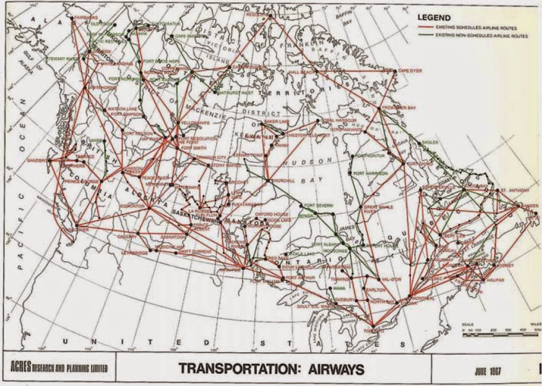


The road coverage as of 1967 certainly leaves something to be desired, but the rail networks seem to offer reasonable coverage of the Corridor, albeit mostly with single track. Air transportation has excellent coverage of the Corridor and would be an ideal way to ferry people quickly. With this ability to move people via air and freight by rail (and as I've previously stated, rail is great for freight), it seems reasonable to assume that settlement could be established easily enough. It is also interesting to note that the Lakehead-produced report suggested use of cargo hovercraft to deal with over-land transport of lighter goods where there are no roads or railways, which is wonderful in all sorts of ways.
 |
| Easily one of my favourite written sections from the book. |
That said, I feel that the aluminum airship (established with a large R&D contribution from the US government) could play a pivotal role in the development of the Corridor. Recent articles from Gizmodo and the crew at Stuff You Should Know have touched on airships. The article from Gizmodo discusses the development of an aluminum-based rigid airship which requires no runways and is capable of carrying 66 tons. The SYSK podcast linked above discusses the ludicrous fuel efficiency of airships, capable of crossing an appreciable fraction of the Earth's circumference with the same fuel it takes for a fixed wing aircraft to simply reach cruising altitude. And, while we're here, welcome to Vodka & Equations! It's the blog that scoffs at cargo hovercrafts while heaping praise upon modern-day dirigibles.


The last thing that would help development of the Corridor immensely is water. Primarily, water is kinda, sorta necessary for human life. One of those limiting factors when you're considering human settlement. You will notice that the proposed corridor should have plentiful water resources, and should do nicely for providing drinking water so long as we don't treat it like Lake Erie. I will also take this opportunity to draw your attention to the undeveloped hydroelectricity potential. In keeping with the theme of things I've proposed which have, in fact, been discussed decades previous, it would appear that I was right in suggesting that Ontario should have potential hydro projects near James Bay should they prove necessary. As previously noted in this blog, hydro power delivers phenomenal energy return on energy invested (roughly 100:1 according to whatever source I was reading). Québec and other places uses such large energy sources to run aluminum smelters because of the incredibly intense energy demand because it is plentiful, reliable, and comparatively inexpensive. It is terribly convenient that metal ores can only be smelted near hydroelectricity sources, and we happen to have both those things right there.
Another issue I'd like to briefly touch on is that of the native reserves in Northern Canada. This is a wild guess on my part, but I feel as though part of the problem with the delivery of services, and thus the low quality of life, to many reserves is the fact that they are so far away from the major urban centers. Perhaps if the Corridor were developed they would have an easier time getting social services and our reserves wouldn't be so horrific?
The picture at the top of this post indicates with green circles smaller established areas which could be dramatically expanded to serve further settlement, and I will briefly [with tongue firmly planted in cheek] point out that it is awfully self-serving for a Lakehead publication to suggest Thunder Bay as a region of dramatic expansion. The thick black line indicates possible extensions to existing infrastructure. It also features existing usable road and railway, but I sincerely doubt that it is possible to pick out such small details. Hopefully with these details outlined, my previous post will seem more feasible, at least economically speaking. There's a lot of potential up there, we just have to seize the opportunity.
Oh, and I'm sure some switchgrass plantations wouldn't go amiss. Those are great for all kinds of things.
Oh, and I'm sure some switchgrass plantations wouldn't go amiss. Those are great for all kinds of things.
NM
No comments:
Post a Comment